Dogs Off-leash

E-Bikes
Unknown

Lakes Basin Road closes for snow. Consult Sierra County road maintenance website about snow closures, typically November through May.
sierracounty.ca.gov/291/Sno…
Overview
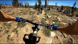
This is designed as a shorter shuttle ride. Overall it's pretty easy technically, but a very fun trail to rip.
Be sure to stop at the Fire Lookout before you head out for your session. Climb the stairs and enjoy an awe-inspiring view. The trail starts just below the peak and heads towards the Graeagle. The upper section is loose shale and slightly challenging while the lower sections go so fast you'll want to do it all over again.
Need to Know
Hwy 89 near Graegle is the Gold Lake Hwy. This is an easy, smooth, paved road. About 10 miles brings you to the Mills Peak Road. Then, just 3 miles of good condition dirt/gravel road to the tower. Nothing steep and the entire route can be done by a car.
Description
This ride starts on the west side of the loop at the end of the road. The trail begins by heading south but soon doubles back and zigzags back and forth across the ridge in a northern direction.
Just about four miles in, this trail turns onto an old jeep track and the speed really picks up. There is a left-hand turn that you don't want to miss, so watch your speed! When the terrain opens up and the jeep track starts to head off the ridge and down to the right; look for the singletrack trail veering uphill to the left. Keep an eye out, I bet you blow right past it.
2 miles later, the trail again intersects a road, this time a pretty good forest service road. Turn left and ride downhill looking for the trail on the right.
The rest of the ride is pure bliss through open woodland on a fast, winding delight. The trail terminates at the corner of Highway 89 & Gold Lakes Highway, it is an easy jaunt into Graeagle for beers.
History & Background
Mills Peak Lookout US 602, CA 73 is on the National Historic Lookout Register. The first Mills Peak Lookout was an L-4 ground house (unusual for California) constructed in 1933. Mills Peak LO was recently restored and reactivated for fire detection in 2005.
Contacts
Shared By:
Lance Buck
with improvements
by Dudley McFadden

 Continue with onX Maps
 Sign in with Facebook


 Intermediate/Difficult

 4.4 (29)


 All Clear


5 Comments