
 Continue with onX Maps
 Sign in with Facebook


 Easy/Intermediate

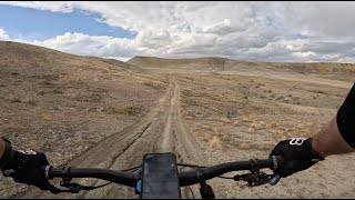
“This doubletrack through the hills above the Gunnison River predates European discovery of the area. ”


4.6
Miles7.3
KMSingletrack
 Easy/Intermediate
Land Manager: BLM Colorado - Grand Junction Field Office
 Holy Cross
2.7 mi 4.3 km • 159' Up 48.47 m Up • 511' Down 155.81 m Down

 Orchard…, CO
 Grand Junction Off-Road 30 Grand Course
29.7 mi 47.8 km • 2,979' Up 908.05 m Up • 2,977' Down 907.37 m Down
Grand Junction Off-Road 40 Grand Course
39.4 mi 63.4 km • 5,483' Up 1671.09 m Up • 5,482' Down 1671.04 m Down
 Flowing Park Loop
15.2 mi 24.5 km • 484' Up 147.53 m Up • 491' Down 149.53 m Down
Black Pine Ridge Loop
6.0 mi 9.6 km • 510' Up 155.6 m Up • 511' Down 155.81 m Down
Redlands, CO
Plunge to Powderhorn
16.8 mi 27.0 km • 555' Up 169.14 m Up • 3,057' Down 931.82 m Down
Cedaredge, CO


0 Comments