
 Continue with onX Maps
 Continue with Facebook


 Easy/Intermediate

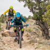
“This doubletrack through the hills above the Gunnison River predates European discovery of the area. ”


4.6
Miles7.3
KMSingletrack
 Easy/Intermediate
Land Manager: BLM Colorado - Grand Junction Field Office
 Grand Junction Off-Road 40 Grand Course
39.4 mi 63.4 km • 5,483' Up 1671.09 m Up • 5,482' Down 1671.04 m Down
 Lunch Loop Trails - Gunny Loop
12.1 mi 19.5 km • 1,362' Up 415.11 m Up • 1,365' Down 416.15 m Down
 Orchard…, CO
Palisade Rim
Orchard…, CO
Palisade Rim
8.7 mi 14.0 km • 1,324' Up 403.69 m Up • 1,329' Down 404.94 m Down
Palisade, CO
 Flowing Park Loop
15.2 mi 24.5 km • 484' Up 147.53 m Up • 491' Down 149.53 m Down
Palisade Plunge: Complete Ride
32.0 mi 51.4 km • 839' Up 255.59 m Up • 6,814' Down 2076.97 m Down
 Tough Enough
37.2 mi 59.9 km • 4,011' Up 1222.69 m Up • 4,018' Down 1224.74 m Down


 All Clear


0 Comments