
 Continue with onX Maps
 Continue with Facebook


 Difficult

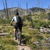
“A rare, relatively non-technical Bitterroot downhill. ”


6.1
Miles9.9
KMSingletrack
 Difficult
Local Club: Bitterroot Backcountry Cyclists
Land Manager: USFS - Bitterroot National Forest Office
 Buttercup Loop
21.1 mi 34.0 km • 2,776' Up 846.17 m Up • 2,781' Down 847.54 m Down

 Ward Mountain
12.5 mi 20.1 km • 4,806' Up 1464.96 m Up • 4,805' Down 1464.62 m Down
 Hamilton, MT
Good Medicine
Hamilton, MT
Good Medicine
19.7 mi 31.7 km • 4,499' Up 1371.33 m Up • 4,488' Down 1367.79 m Down
Sapphire Crest
20.5 mi 33.0 km • 2,965' Up 903.81 m Up • 5,129' Down 1563.33 m Down
Hamilton, MT
Rombo Mountain
16.3 mi 26.2 km • 3,146' Up 958.93 m Up • 3,905' Down 1190.19 m Down
Hamilton, MT
Warm Springs Ridge
20.0 mi 32.2 km • 1,899' Up 578.93 m Up • 4,628' Down 1410.58 m Down
Salmon, ID


0 Comments