Use onX Backcountry to explore the terrain in 3D, view recent satellite imagery, and more.
Now available in onX Backcountry Mobile apps!
For more information see this post.
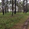
This loop features nice flowy singletrack with little elevation change. It can however, be ridden at a pretty fast pace. The southern section of the trail is one of the primary routes for accessing the rest of the San Felasco trails from the trailhead, so there can be quite a bit of two-way traffic. There are some blind curves due to vegetation along this route so be aware of riders that may be coming the other direction. The northern most part of the loop is sometimes flooded depending on the amount of recent rains.
Moderately steep. Uneven terrain with small rocks or roots.
Sizable rocks & roots. Steep sections.
Steep. Some technical terrain and limited alternate lines.
Very steep. Technical terrain with no alternate lines.
Difficulty Rating
Average from 6 votes:
Easy
Your Rating
Virtual Tour of Cellon Creek Loop
We use cookies to improve your browsing experience, to show you
personalized content, and for statistical purposes. By continuing
to navigate our website, you accept our use of cookies. Read our
Privacy Policy to learn more.

 Continue with onX Maps
 Continue with Facebook


 Bad / Closed


0 Comments