Dogs Leashed

E-Bikes
Unknown
Overview
This ride has a little something for everyone. Scenery and wildlife along the creeks, fast and fun berms, oak savannahs, and prairie sections. Everything from flat tight twisty trails, berms and rollers, fast and flowy sections, to sketchy rock sections. It is all singletrack with some great views and feels like you are deep in the woods, though you are never far from the gravel connector trail. A quick exit is easily accessible if needed for a mechanical or other emergency.
Need to Know
- All riders much purchase a Dane County Trail Pass ($16 annually or $5 daily). Passes can be purchased at the park kiosks or online under the "Trail Permits" section, here.
- Trails are well signed and mapped. Each trail sign has an emergency code. Use that code with 911 if you are in an emergency and they will know exactly where you are and how they can best get to you.
Description
CamRock Park is located between Rockdale and Cambridge along the Koshkonong Creek. This route leaves from CamRock 3, but it's not uncommon for riders to start from CamRock Sport and from the north for a longer ride that starts at the bike shop and eatery.
From the parking area at CamRock 3, check out the views down the valley from the top of the hill. There are three options to choose from to start downhill.
Getting Started is the easiest option and is still fun. But the tight and steep berms of
Beer Run are the local's favorite.
Next, make your way north along
Mayor's Meander and then onto the west side of the
Corp Connector Loop at the Rockdale Roundabout. You'll find lots of meadows and prairies typical of CamRock. If you're out riding at the right time of year, the blooms are simply amazing and can be tall enough to tower over your head. Anticipate some quicky punch climbs and bermed downhills. Be sure to throw in
Heather's Hill into the mix for some added flavor.
At the top of the
Corp Connector Loop, head left onto
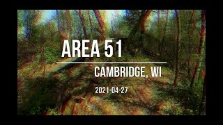
IMBA Influence or Area 51 to reach the start of the
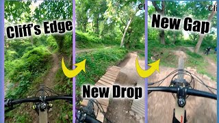
Outback Trail. This pouplar trail is really intermediate, but it has expert options. Try your skill and test your mettle here on plenty of log rides, bridges, berms, step-ups, and even a huge tree/log ride called Big Woody that is over four feet off the ground. That will keep your attention! But don't fret, all of the more technical features have ride-around options. Riders could also stick to
IMBA Influence and
Veritas for easier passage.
Follow
Veritas back down to the
Corp Connector Two-Way Trail and turn right to reconnect to the
Corp Connector Loop. This time, continue straight to ride south along the east side of the loop. After a bit of pedalling, riders will reach the start of
Raspberry Fields where the fun really gets going. You'll fly over some rollers before it feeds into
Rip N Ride.
This local's favorite is the perfect time to let er' rip and ride it out! It has air, step-downs, and berms through a big 'ol gully that is a blast. Or just take it a little slower to lower the challenge - it's still fun either way. In the summer season there are beautiful praire blooms here. Once back on the
Corp Connector Loop, follow it to the Rockdale Roundabout.
Last on this route are the wooded sections of
Turn It Up,
Stonefly,
Woodchuck,
Corkscrew, and
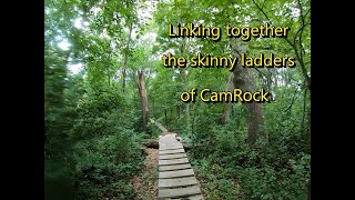
Rattlesnake. These are all beautiful old-growth Oak forested areas, and the original sections of CamRock Trail. As such, there's a lot of up and down. These trails have been improved to make them more sustainable, but they managed to keep their "old school" feel. You won't find rolling flow trail here. Instead, there are sections of tech where the singletrack travels through old rock quarries. Expect some rock and areas of loose tread that can be intemidating for newer riders.
The end of
Rattlesnake will despoit riders back at the parking area at the start of the ride. Either go in search of refershement at the Rockdale Bar and Grill, or head out for some more riding!
History & Background
This area was dammed and cleared bare of trees in the 1800's for building the local Village of Rockdale. The Rockdale Mill Pond was drained in 1998 and the creek was free to flow for the first time since 1837. Take some time to view the beautiful old Oak trees, part of an Oak Savannah. Also stop and view the restored prairies and all of the beautiful flowers in the mid to late summer. Notice the rocky sections of trail where quarries were dug out to make bricks for local homes and businesses in the early to late 1800's, including the Rockdale Brick Company. The old brewery (now a home) on the south edge of Rockdale along B, is the perfect example of this brickwork. The brewery also used the
Beer Cave for lagering their beer. Look for the cave, in dire need of restoration, along the
Beer Cave trail.
Contacts
Shared By:
Nate Castner

 Continue with onX Maps
 Sign in with Facebook


 Intermediate/Difficult

 4.3 (50)


 Minor Issues


3 Comments