Dogs Unknown

Overview
The Kern River Trail (31E75) begins at Pearl Harbor Drive in Keyesville Recreation Area. There are moderate, rideable grades and fairly substantial elevation changes as the trail climbs above the Kern River through mostly open hillsides of grass and oak trees. There can be excellent wildflower displays along this trail from mid-March to late April. Intermediate riders.
Need to Know
The best way ride this trail is to set up a shuttle and ride from Keyesville down to the Delonegha bridge. The GPS indicated 3400 feet of ascent and 3700 feet of descent. The occasional motorcycle uses the route so use caution. Other hazards include rattlesnakes and steep descents. Make sure to bring lots of water if you're crazy enough to try it in Summer.
Description
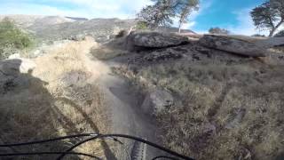
The trail takes off from the high point of the Keyesville classic and heads west above the Kern River. Stage at the Keyesville staging area and ride clockwise on the Keyesville classic until you reach the ridge line and see the sign for the Kern River trail which dives off the ridge to the west. Expect great views and gorgeous wildflower displays in spring.
The Kern River Trail crosses a couple of good sized ridge lines, but almost all the grades are rideable by the moderate rider. The biggest climb comes in at about the 10-mile mark when you climb from 2400 feet up to 3200 feet. The last 6 miles is almost entirely downhill and drops from the high point of 3200 feet down 1200 feet to the parking lot.
There are starting to be a few spots where ruts are forming that will either force you to walk due to the rut being deeper than pedal level. This is also causing the trail to wide in sections. other hazards include snakes, sand and summer heat.
It's primo smooth singletrack. There are a couple of trail junctions that are well marked but as always bring a map and compass and know how to use them. The lower staging area is the Delonegha bridge turn out. Jump in the river to soothe sore muscles then jump in the car to head 11 miles back to the Keyesville Staging area. Grab your other car then head up to Kernville for a cold one at the Kern River Brewery.
History & Background
A classic route maintained by the volunteer efforts of the Southern Sierra Fat Tire Association and Stewards of the Sequoia.
Contacts
Shared By:
Brie Chartier

 Continue with onX Maps
 Sign in with Facebook


 Intermediate/Difficult

 4.6 (14)


7 Comments