Ride along Portola Pkwy, a busy suburb street, for about a mile and turn right after passing the Ralphs super market. The trailhead is on the left of Ralphs. Follow the snaking
Borrego Trail for 1.5 miles through sandy, creek-bottom, tree and cactus-filled terrain that climbs only slightly. Be alert, there have been numerous mountain lion sightings through this sliver of a canyon. Ride with someone. Think and act BIG.
Borrego merges into a wide dirt trail,
Mustard Road. The road twists steeply up to the left, disappearing behind the hillside (if you go left, climb the small singletrack on the right after a few hundred feet. This is a super fun, extra credit wrinkle called Cattle Pond Loop that re-joins
Mustard Road close to where it left.) To the right, the trail bends around a trail kiosk, then onto a few more easy turns. However, don't be fooled, the easy turns hide the brutal 3/4th-mile climb to Four Corners. Around the last blind right turn, climb the final rise to Four Corners, a convergence of trails from all directions. With amazing views, a trail kiosk, benches and a drinking fountain, it's a great place for a break.
Climb the uphill trail to the left, behind the bench/kiosk. This will take you down to Santiago Canyon Rd, a 55mph twisting, paved road. Head east, downhill, for about a quarter-mile, very carefully cross the road and turn left, uphill, on Modjeska Grade Rd, an extremely steep, paved road. In less than a half-mile, slide past the low, rusted gate on the right into a large, dirt staging area with a great view of the mountains beyond. A well established singletrack called
Santiago Truck Trail rises into the barren, rocky landscape colored by pale desert plants and infinite shades of brown.
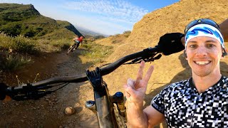
The climb is long. There's a few steep slopes. But there's nothing long... AND steep. The views south and west over south Orange County are stunning. After nearly three miles of climbing, the trail lightly descends, flattens, then becomes a strip perched atop the mountains razor edge. Look ahead and right of the trail and notice a dome-shaped hill flying a large American flag proudly, ammo boxes filled with notebooks and pens chained to its pole. Rest. Take a picture. Sign the book.
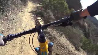
Leaving flag hill, at first the slope is moderate. The trail begins its cliff-side exposure, twisting easily a few times to a right-hand bend featuring drop-offs on each side. From there
The Luge gets steep as the trail becomes a bobsled half-pipe, snaking along the cliff, with one-foot rock ledges and stones, loose and embedded, spread generously along its one-plus mile length. It will pound your body with a constant stream of impacts, and your forearms and calves will scream from the relentless push downhill.
At the end, make your way to Live Oak Canyon Rd, a 35mph paved road, and turn right. Live Oak tilts steeply downhill and soon you'll be nearing the speed limit, so be careful. At the famous Cook's Corner turn right on Santiago Canyon Rd and, from well outside the white line, climb the almost perfect 5% grade for one mile. On the left, across the road, enter the Santiago Equestrian Center and, between the building and the hillside, follow the dirt fire road up to the ridge.
There are two trails back into Whiting Ranch from here - Vulture View up to the left, and
Santiago Ranch Rd down to the right. Both ways will eventually get to the same place,
Sage Scrub Trail. Then it's just a matter of finishing the
Whiting Ranch Loop.

 Continue with onX Maps
 Sign in with Facebook


 Intermediate/Difficult

 4.2 (42)


 Minor Issues


0 Comments