Alpine starts at the intersection of FS 1912 and FS 1825 and mostly climbs through classic Oregon forests to Kate's Cut-In where most people start Alpine.
Start from the road and turn left onto Kate's Cut-In. There will be a quick switchback to the right and then you'll have a short climb to the Alpine intersection. Turn left again. The trail climbs gradually through big trees to a large grassy meadow. Enjoy a brief flat section before diving back into trees, rolling towards the first sustained descent.
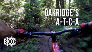
The crossing of a short narrow ridge signifies a fast descent ahead. This one goes quickly with long runs of trail intermixed with turns and switchbacks.
This section ends at a road, cross and roll into an uphill section that leads to another big descent nicknamed 'Jedi'. This dark and fast section of forest ends at Windy Pass, a major road intersection.
From here there is an easy pedaling climb through a new section. It ends at yet another road. From here you'll be on a rehabbed road, now a trail, that climbs through a series of surfaced 's' turns.
There's a brief respite and then the route continues to climb. The forest opens up to big trees and steep, lush, lichen-leaden side slopes to an incredible view at a high meadow. This is a great place to stop for a snack break and take in the views.
From here Alpine rolls past the Tire Mountain intersection (turn right here if riding
A-T-C-A) and then descends continuously through fast, flowy turns and beautiful forest down to the Buckhead Shelter. There are a few sections that rise along the way but you'll have enough speed to carry through.
From the shelter, there's another round of brief climbing followed by sustained descent to a road. After crossing, you'll experience another descent, one of the the rowdiest on Alpine with tight turns and some scrabbly texture.
Afterward, you'll get a little break from being on the brakes as you pedal through flatter terrain. The trees are beautiful through here, covered in multi-hued lichens up and down their trunks.
Stay straight through multiple road crossings then dive into a fast and narrow trail that has long, straight runs. At the last intersection, make a hard left onto the
Westfir Tie and fly to the finish at the bottom of the road. Turn right to cruise back to parking lot at the red bridge.

 Continue with onX Maps
 Sign in with Facebook


 Intermediate/Difficult

 4.5 (62)


9 Comments