Continue with onX Maps
 Sign in with Facebook


Santa Fe National Forest
 NM
NM- North Central New Mexico
- Santa Fe National Forest


Overview
Some of the most exquisite alpine scenery in the Southwest is found in this National Forest. Here, you can find the headwaters of Pecos, Jemez, and Gallinas Rivers; mountain streams; lakes; and trout fishing. Consider visiting one of many nearby Indian pueblos, Spanish missions, and Indian ruins. Golden aspens grace the high country from September to October and snow blankets Santa Fe Ski Basin in winter.
Recommended Routes in Santa Fe National Forest - 3
MTB Project is built by riders like you. Add Your Recommended Routes


Santa Fe National Forest Biking
- 70 Miles 113 Kilometers of Trail
- 3 Recommended Routes
- 3
Easy Trails

- 25
Intermediate Trails

- 11
Difficult Trails

MTB Project is built by riders like you. Share
what you know about this area!
Areas Within Santa Fe National Forest
Weather Averages
|
High
|
Low
|
Precip
|
Days w/
|
| J | F | M | A | M | J | J | A | S | O | N | D |
Trails in Santa Fe National Forest - 36
MTB Project is built by riders like you. Add Your Trails
1.6
mi
2.5
km
#1Holy Molé
 Intermediate/Difficult
Pecos, NM

|
Intermediate/Difficult
|
Pecos, NM |
24
|
|
1.3
mi
2.0
km
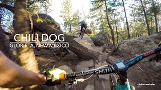
#2Chili Dog
 Difficult
Pecos, NM
|
Difficult
|
Pecos, NM |
15
|
|
|
2.7
mi
4.4
km
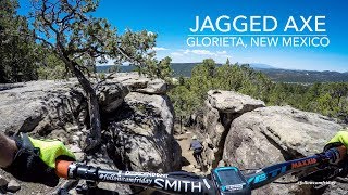
#3Jagged Axe
Difficult
Pecos, NM
|
Difficult
|
Pecos, NM |
12
|
|
|
1.4
mi
2.3
km
#4Chips and Salsa
Intermediate/Difficult
Pecos, NM
|
Intermediate/Difficult
|
Pecos, NM |
9
|
|
4.2
mi
6.8
km
#5Cairn Me Up
 Intermediate
Pecos, NM
|
Intermediate
|
Pecos, NM |
8
|
|
0.6
mi
0.9
km
#6Janker DH
 Very Difficult
Pecos, NM
|
Very Difficult
|
Pecos, NM |
5
|
|
|
0.7
mi
1.1
km
#7Upper Ruiz
Intermediate
Pecos, NM
|
Intermediate
|
Pecos, NM |
2
|
|
|
0.9
mi
1.4
km
#8Ruiz Canyon
Intermediate
Pecos, NM

|
Intermediate
|
Pecos, NM |
4
|
|
|
1.8
mi
2.9
km
#9Snack Pack
Intermediate
Pecos, NM
|
Intermediate
|
Pecos, NM |
11
|
|
|
1.3
mi
2.1
km
#1030 Acre Wood
Intermediate
Pecos, NM
|
Intermediate
|
Pecos, NM |
2
|
Photos of Santa Fe National Forest - 180
MTB Project is built by riders like you. Add Your Photos