Continue with onX Maps
 Sign in with Facebook


Behind the Rocks
 UT
UT- …Southeastern Utah
- Moab
- Behind the Rocks


Local Info
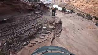
Behind The Rocks MTB happens in the area immediately south and west of the Wilderness Study Area, and east of and atop the tall cliffs bordering Kane Creek. This beautiful and remote area is bounded on the south by HWY 191, and to the north by the Colorado River.
The BTR WSA encompasses the tortured maze of sandstone fins that form the western wall of Spanish Valley where the town of Moab lies. Well-hidden arches, narrow canyons, ruins, and rock formations make for fantastic rest day exploring, but bikes are not allowed in the WSA...not that they'd be much help in this rugged and largely vertical terrain.
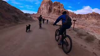
For 18 years, the 24-Hours of Moab race was held here each fall, often in freezing temps and blowing snow. Teams of riders competed to see who could complete the most laps of the 15-mile course, riding through the day and night and partying between turns in the saddle. A few hardy souls even rode the whole thing alone. The event was very popular, despite being known for its punishing sand and weather. The vibe was like Burning Man in its huge temporary village, joyful atmosphere, and repeat attendees and teams.
Since those days, BTR has fallen into relative MTB obscurity. The area's extensive road network is more popular with OHVs and horses, though running events usually pass through a couple of times a year. The infamous sand is one reason for the decline, as is MTB's more recent focus on flowy (easy) singletrack and enduro-style downhills, neither of which can be found here.
However, the local situation may be changing. Larger tires, fat bikes and e-bikes make sand more rideable, and there is less of it now on many of these trails than there was, due to OHV-caused erosion down to the underlying sandstone slickrock and ledges in many places. And bikepackers are rediscovering the adventure that the MTB community used to value above riding conditions.
You should still be selective about when to ride Behind The Rocks: come after recent precipitation for the most consolidated conditions, and pay attention to recommended trail riding direction. Avoid popular holidays when the OHVs will have churned the sand. Winter is a great time to be here; visiting after the range cows have left in late winter when the grass is gone is best—they can churn up the sand, too. And if—in spite of your precautions—you find sand too deep to be enjoyable, go to Plan B and return another day!
Bikepacking and camping in the area works well. With a mix of State and BLM land, there is lots of dispersed primitive no-fee camping, though holidays and weekends may be best left to the motorheads. There is no water available (stock up at Gearheads), and you shouldn't gather wild firewood. Stay on real roads, obey closures, use existing hardened campsites, and clean up your campfire messes! There is private property in the area, so please be respectful.
Access to the BTR area is primarily from the south, off of HWY 191 12-miles south of the Moab Information Center. But you can also ride up (and/or exit via) Pritchett Canyon from the Colorado River. The Moab Rim trail can be used to reach the northern corner of BTR, though it's difficult to connect through.
The BTR WSA encompasses the tortured maze of sandstone fins that form the western wall of Spanish Valley where the town of Moab lies. Well-hidden arches, narrow canyons, ruins, and rock formations make for fantastic rest day exploring, but bikes are not allowed in the WSA...not that they'd be much help in this rugged and largely vertical terrain.
For 18 years, the 24-Hours of Moab race was held here each fall, often in freezing temps and blowing snow. Teams of riders competed to see who could complete the most laps of the 15-mile course, riding through the day and night and partying between turns in the saddle. A few hardy souls even rode the whole thing alone. The event was very popular, despite being known for its punishing sand and weather. The vibe was like Burning Man in its huge temporary village, joyful atmosphere, and repeat attendees and teams.
Since those days, BTR has fallen into relative MTB obscurity. The area's extensive road network is more popular with OHVs and horses, though running events usually pass through a couple of times a year. The infamous sand is one reason for the decline, as is MTB's more recent focus on flowy (easy) singletrack and enduro-style downhills, neither of which can be found here.
However, the local situation may be changing. Larger tires, fat bikes and e-bikes make sand more rideable, and there is less of it now on many of these trails than there was, due to OHV-caused erosion down to the underlying sandstone slickrock and ledges in many places. And bikepackers are rediscovering the adventure that the MTB community used to value above riding conditions.
You should still be selective about when to ride Behind The Rocks: come after recent precipitation for the most consolidated conditions, and pay attention to recommended trail riding direction. Avoid popular holidays when the OHVs will have churned the sand. Winter is a great time to be here; visiting after the range cows have left in late winter when the grass is gone is best—they can churn up the sand, too. And if—in spite of your precautions—you find sand too deep to be enjoyable, go to Plan B and return another day!
Bikepacking and camping in the area works well. With a mix of State and BLM land, there is lots of dispersed primitive no-fee camping, though holidays and weekends may be best left to the motorheads. There is no water available (stock up at Gearheads), and you shouldn't gather wild firewood. Stay on real roads, obey closures, use existing hardened campsites, and clean up your campfire messes! There is private property in the area, so please be respectful.
Access to the BTR area is primarily from the south, off of HWY 191 12-miles south of the Moab Information Center. But you can also ride up (and/or exit via) Pritchett Canyon from the Colorado River. The Moab Rim trail can be used to reach the northern corner of BTR, though it's difficult to connect through.
Recommended Routes in Behind the Rocks - 1
MTB Project is built by riders like you. Add Your Recommended Routes

 No Photos
Behind the Rocks Biking
- 66 Miles 107 Kilometers of Trail
- 1 Recommended Route
- 0
Easy Trails

- 6
Intermediate Trails

- 8
Difficult Trails

MTB Project is built by riders like you. Share
what you know about this area!
Weather Averages
|
High
|
Low
|
Precip
|
Days w/
|
| J | F | M | A | M | J | J | A | S | O | N | D |
Trails in Behind the Rocks - 13
MTB Project is built by riders like you. Add Your Trails
5.8
mi
9.4
km
#1Pritchett Canyon Jeep Road
 Difficult
Moab, UT

|
Difficult
|
Moab, UT |
7
|
|
1.1
mi
1.8
km
#2Prostitute Butte Loop
 Intermediate
Moab, UT
|
Intermediate
|
Moab, UT |
1
|
|
|
3.5
mi
5.6
km
#3Moab Rim Trail
Difficult
Moab, UT
|
Difficult
|
Moab, UT |
15
|
|
|
3.9
mi
6.2
km
#4Hunter Canyon Rim
Difficult
Moab, UT

|
Difficult
|
Moab, UT |
3
|
|
|
3.2
mi
5.2
km
#5Hidden Valley
Difficult
Moab, UT
|
Difficult
|
Moab, UT |
13
|
|
1.4
mi
2.2
km
#6The Water's Way Out
 Easy/Intermediate
Moab, UT
|
Easy/Intermediate
|
Moab, UT |
1
|
|
|
14.5
mi
23.3
km
#7Behind the Rocks Road
Easy/Intermediate
Moab, UT
|
Easy/Intermediate
|
Moab, UT |
7
|
|
10.9
mi
17.5
km
#824-Hours of Moab Route
 Intermediate/Difficult
Moab, UT
|
Intermediate/Difficult
|
Moab, UT |
10
|
|
|
2.5
mi
4.0
km
#9Two Arches
Difficult
Moab, UT
|
Difficult
|
Moab, UT |
2
|
|
|
1.8
mi
3.0
km
#10Behind the Rocks Loop Shortcut
Intermediate/Difficult
Moab, UT
|
Intermediate/Difficult
|
Moab, UT |
2
|
|
|
13.8
mi
22.1
km
#11Kane Creek Canyon Trail
Difficult
Moab, UT
|
Difficult
|
Moab, UT |
6
|
|
|
3.3
mi
5.3
km
#12Old Spanish Trail Cut-Off
Intermediate
Moab, UT
|
Intermediate
|
Moab, UT |
2
|
|
0.8
mi
1.3
km
#13Rubble Hill (Behind The Rocks - Hwy 191 Connector)
 Very Difficult
Moab, UT
|
Very Difficult
|
Moab, UT |
1
|
Photos of Behind the Rocks - 41
MTB Project is built by riders like you. Add Your Photos