
 Continue with onX Maps
 Continue with Facebook


 Intermediate

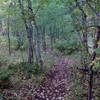
“A singletrack with stream crossings on bridges and rocks with abundant foliage. ”


2.5
Miles4.0
KMSingletrack
 Intermediate
Land Manager: USFS - Black Hills National Forest Office
 Gold Rush Gravel Grinder
114.8 mi 184.7 km • 6,654' Up 2028.29 m Up • 6,648' Down 2026.37 m Down
 Spearfish, SD
 Cole Canyon Loop
22.3 mi 36.0 km • 3,588' Up 1093.76 m Up • 3,590' Down 1094.27 m Down
 2 Flat Junction Ride
10.0 mi 16.1 km • 1,323' Up 403.12 m Up • 1,320' Down 402.48 m Down
Centennial Trail-Bulldog Climb
8.2 mi 13.3 km • 885' Up 269.88 m Up • 885' Down 269.72 m Down
Sturgis, SD
 Quality Over Quantity
12.8 mi 20.6 km • 1,896' Up 578.04 m Up • 1,894' Down 577.15 m Down
Centennial Trail Elk Creek TH to Alkali TH
11.2 mi 18.1 km • 1,189' Up 362.34 m Up • 2,238' Down 682.14 m Down
Sturgis, SD


0 Comments