
 Continue with onX Maps
 Continue with Facebook


 Easy
Easy

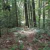
“A gravel Forest Service road that accesses the Currin Valley Trail. ”


4.1
Miles6.6
KMDoubletrack
 Easy
Easy
Land Manager: USFS - George Washington & Jefferson National Forests
 The Long Loop
12.5 mi 20.1 km • 1,903' Up 579.98 m Up • 1,925' Down 586.69 m Down

 Marion, VA
 Rowland Falls to Jerry's Creek
12.5 mi 20.2 km • 2,025' Up 617.1 m Up • 2,028' Down 618.08 m Down
 Forest Trail
1.1 mi 1.7 km • 231' Up 70.34 m Up • 243' Down 74.12 m Down
Rural R…, VA
Rush Creek Loop
13.7 mi 22.0 km • 2,461' Up 750.01 m Up • 2,451' Down 747.12 m Down
Chilhowie, VA
Virginia Highlands Loop
74.8 mi 120.3 km • 6,737' Up 2053.31 m Up • 6,738' Down 2053.59 m Down
Bikepacking Pulaski to Damascus
122.9 mi 197.8 km • 9,173' Up 2795.81 m Up • 9,179' Down 2797.78 m Down


0 Comments