Use onX Backcountry to explore the terrain in 3D, view recent satellite imagery, and more.
Now available in onX Backcountry Mobile apps!
For more information see this post.
“A winding route though hardwood bottoms and pine plantations.
”
Closed the first Tuesday in January to the first Thursday in March. Avoid during the first two weeks of rifle hunting season.
Description
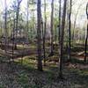
The Cedar Springs OHV trail is a winding route through hardwood bottoms and pine plantations. There's little elevation change, making the route enjoyable for novice to more experienced riders.
Throughout the trail, you'll find a natural, hard-packed clay surface mixed in with a few sections of gravel. The most challenging area of the trail is littered with large, basketball-sized rocks.
Moderately steep. Uneven terrain with small rocks or roots.
Sizable rocks & roots. Steep sections.
Steep. Some technical terrain and limited alternate lines.
Very steep. Technical terrain with no alternate lines.
Difficulty Rating
Average from 2 votes:
Easy/Intermediate
Your Rating
Virtual Tour of Cedar Springs OHV Trail
We use cookies to improve your browsing experience, to show you
personalized content, and for statistical purposes. By continuing
to navigate our website, you accept our use of cookies. Read our
Privacy Policy to learn more.

 Continue with onX Maps
 Continue with Facebook


 Easy/Intermediate


 Minor Issues


1 Comment