
 Continue with onX Maps
 Continue with Facebook


 Easy/Intermediate

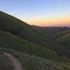
“Enjoy fantastic views both east and west as you travel the southernmost section of the Boise Ridge. ”


5.1
Miles8.2
KMDoubletrack
 Easy/Intermediate
Land Manager: USFS - Boise National Forest Office
 Watchman Chicken Leg Burner
13.9 mi 22.3 km • 2,288' Up 697.31 m Up • 2,280' Down 694.95 m Down
 Red Cliff to Bobs to Lower Hulls
9.9 mi 15.9 km • 1,504' Up 458.56 m Up • 1,508' Down 459.49 m Down
 Boise, ID
 Danskins Tour
14.2 mi 22.9 km • 2,008' Up 612.17 m Up • 2,015' Down 614.08 m Down
 Dry Creek to Shingle Creek then Descend Dry Creek
14.1 mi 22.7 km • 2,211' Up 673.96 m Up • 2,212' Down 674.2 m Down
Boise, ID
Stack Rock Loop
11.4 mi 18.3 km • 1,144' Up 348.62 m Up • 1,146' Down 349.2 m Down
Boise, ID
BB Bomber
27.4 mi 44.2 km • 2,060' Up 627.92 m Up • 4,923' Down 1500.6 m Down
Boise, ID


0 Comments