
 Continue with onX Maps
 Continue with Facebook


 Difficult

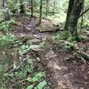
“Tea Creek Trail links Mine Road south to Tea Creek Campground, accessing many singletrack trails. ”


7.0
Miles11.3
KMSingletrack
 Difficult
Local Club: Pocohontas Trails
Dec 4, 2023: Poca Trails December Meeting- December 7th, 2024 @ Old Spruce Brewing
Jun 20, 2023: Enduro Trail Work Day – July 9th, 2023
Jun 20, 2023: Poca Trails Meeting – June 27th, 2023
Land Manager: USFS - Monongahela National Forest Office
 Distilled Tea Creek
24.4 mi 39.3 km • 2,570' Up 783.32 m Up • 2,563' Down 781.27 m Down
 Marlinton, WV
 Silver Creek Route
8.0 mi 12.9 km • 1,002' Up 305.41 m Up • 1,033' Down 314.75 m Down

 Bruffey and the Boys
5.7 mi 9.2 km • 431' Up 131.33 m Up • 427' Down 130.14 m Down
Marlinton, WV
 Dogway Glades Loop
23.7 mi 38.2 km • 1,441' Up 439.31 m Up • 1,454' Down 443.08 m Down
South Fork Loop
11.4 mi 18.4 km • 1,363' Up 415.46 m Up • 1,378' Down 419.91 m Down
Whitmeadow - Stonecoal Loop
13.8 mi 22.2 km • 1,403' Up 427.72 m Up • 1,381' Down 420.9 m Down
Elkins, WV


1 Comment