Dogs Unknown

E-Bikes
Unknown
Need to Know
Dangerous, aggressive dog at the Barking Dog section of the trail. Short distance south of the Chase Overlook. Bring bear spray and a loud voice .Don't turn your back on this mutt! Large, brown, seems to live above the trail. I have had more than one contact with this creature.
Description
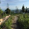
This trail begins at the upper end of
Chase Trail. This is the point in the Herron trail system where it makes sense to carry bear spray since this route is isolated and fewer humans are around to scare the furry friends away.
In two miles take a right to stay on the singletrack.
This section is more of a rough and rocky romp featuring one tough rock feature to clear and two short but steep and loose climbs. Rip through this section until the trail intersects with another dirt logging road. Head left on the logging road until it terminates and you can see the singletrack start up again on your right side and head South. Depending on conditions this section is occasionally another hike a bike for about 50 ft but becomes a steep, narrow path until you hit a three way intersection and stay right towards Blacktail.
This trail passes through a big 6-way logging road intersection, take the Southern most and the singletrack picks up again on your left, marked with a pink flag, and heads directly uphill. In 300m you'll hit some logging road, stay left and ride it another 300m to the singletrack on your right. From here, the trail sticks with some great singletrack for a while.
In about two miles you'll pop out at a dirt road, cross this and ride past the green gate onto the logging road across from the trail. Ride this for a while, over 3 miles, it's not singletrack but it's a fun and pretty section to ride. Just over 3 miles the trail makes a sharp bend around a draw. Don't follow this, the singletrack continues directly up the draw on your left. It remains singletrack from here. You'll pass the
Blacktail to Lakeside Trail and after that it's a steep climb to the top of Blacktail.
Contacts
Shared By:
matt hoyne
with improvements
by mike reeves

 Continue with onX Maps
 Continue with Facebook


 Difficult


1 Comment