
 Continue with onX Maps
 Continue with Facebook


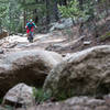
 Difficult

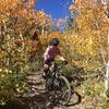
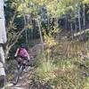
“The best downhill trail in the Dot Trails/East Magnolia area. ”


0.8
Miles1.4
KMSingletrack
 Difficult
Land Manager: Boulder County, CO - Parks and Open Space
 Rhythm & Blues
10.3 mi 16.6 km • 825' Up 251.57 m Up • 825' Down 251.49 m Down

 Nederland, CO
 The Cougar Slayer
69.6 mi 112.0 km • 8,965' Up 2732.51 m Up • 11,815' Down 3601.28 m Down
Nederland, CO
The N Bus Loop
13.0 mi 21.0 km • 1,490' Up 454.13 m Up • 1,489' Down 453.83 m Down
Nederland, CO
East Mag Dots
13.8 mi 22.2 km • 1,075' Up 327.67 m Up • 1,074' Down 327.27 m Down
Walker Ranch
7.8 mi 12.6 km • 1,516' Up 462.02 m Up • 1,510' Down 460.32 m Down
South Saint Vrain Figure 8
16.3 mi 26.2 km • 2,072' Up 631.58 m Up • 2,086' Down 635.74 m Down


0 Comments