
 Continue with onX Maps
 Continue with Facebook


 Difficult

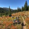
“A great access route heading straight into the heart of the Smokys. ”


10.2
Miles16.4
KMDoubletrack
 Difficult
Local Club: Wood River Trails Coalition
Land Manager: USFS - Sawtooth National Forest - Ketchum Ranger District
 The Big Smokey Loop
57.3 mi 92.2 km • 5,111' Up 1557.96 m Up • 5,108' Down 1557.02 m Down
 Decker Creek Loop
22.0 mi 35.4 km • 4,212' Up 1283.96 m Up • 4,246' Down 1294.14 m Down
 Idaho City, ID
Big Smoky Trail
Idaho City, ID
Big Smoky Trail
18.4 mi 29.6 km • 234' Up 71.4 m Up • 2,936' Down 894.77 m Down
Idaho Trail Segment 5
37.3 mi 60.0 km • 4,705' Up 1433.94 m Up • 3,027' Down 922.7 m Down
Sun Valley, ID
Graham-Horse Heaven Loop
54.6 mi 87.9 km • 7,240' Up 2206.72 m Up • 7,238' Down 2206.22 m Down
Idaho City, ID
Big Bowery Loop
36.4 mi 58.6 km • 4,382' Up 1335.59 m Up • 4,381' Down 1335.44 m Down


0 Comments