
 Continue with onX Maps
 Continue with Facebook


 Difficult

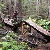
“A more fall line oriented version of Kashmir. ”


0.4
Miles0.6
KMSingletrack
 Difficult
Local Club: WORCA
 Top of the World to Khyber to Kashmir to Kush to Big Timber
10.0 mi 16.1 km • 1,131' Up 344.82 m Up • 6,092' Down 1856.88 m Down

 Whistler, BC
 Whistler's Alta Lake Technical Tour
11.1 mi 17.9 km • 1,576' Up 480.34 m Up • 1,577' Down 480.79 m Down
Whistler, BC
 Best of Whistler Village Cross Country
13.7 mi 22.0 km • 940' Up 286.52 m Up • 929' Down 283.21 m Down
Kill Me Thrill Me
3.7 mi 5.9 km • 576' Up 175.5 m Up • 775' Down 236.35 m Down
Whistler, BC
Comfortably Numb - IMBA Epic
13.9 mi 22.3 km • 2,118' Up 645.47 m Up • 2,086' Down 635.75 m Down
Whistler, BC
Out There Ride
2.6 mi 4.1 km • 702' Up 213.98 m Up • 701' Down 213.57 m Down


0 Comments