Dogs Off-leash

E-Bikes
Unknown
Description
Ride this before it becomes Wilderness Area.
This trail is typically ridden as a shuttle ride. Most people leave a car at the bottom trailhead, near the Arlington WY exit on I-80 (#272). From there, you can drive around to the top trailhead near the Deep Creek CG on the Sand Lake Road (FR 101), which is about 24 miles from Centennial, WY. That said, we have started making a loop out of it frequently.
To ride this trail as a loop, you still drive to the bottom trailhead, but then ride about 16 miles up to the top trailhead and descend back to the car for a nice day ride. There are 2 road options and the nicest one is to head up the wicked hill of FR 129. It breaks into beautiful Aspen groves and some enchanted forest like areas before turning into an old logging area. FR 129 has a couple of options - FR130 or continue on to FR111 but they all end up at the same place. FR111 merges onto FR113 which goes all the way to the upper TH.
Another option which will be written up soon is to come down onto the trailhead from above, by descending the Sheep Lake Trail via Brooklyn Lake Road. This adds 8 miles of primitive trail, or can be done as a Whopper of 30+ miles from the Centennial Visitor Center, up
North Fork Trail, as a big Feature Ride.
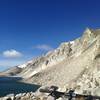
Once on the Rock Creek Trail, the descent along Deep Creek is a nice grade that gets progressively more technical. The canyon deepens dramatically and the confluence of Deep Creek and Rock Creek marks a change to some challenging side hills with some exposure. Side creeks from the left side (going downhill) with bridges make it really fun and scenic.
Stop for lunch at Carlson Creek bridge and take a dip in the pools below.
Several large talus slopes will challenge all but the most nimble, or those with the biggest forks or huevos. The hits keep coming until you suddenly drop onto the trailhead (or trail tail?) and hopefully you left a stocked cooler waiting there.
Contacts
Shared By:
John Marno

 Continue with onX Maps
 Continue with Facebook


 Difficult


9 Comments