Dogs Unknown

E-Bikes
Unknown
Overview
This is a great XC ride to get your legs moving in the spring, as its lower elevation allows it to dry out a little sooner than other Kananaskis trails. In the fall, there are fantastic views available from the high points of the north section, where you'll see pockets of aspen and poplar turning gold and yellow amid the sea of coniferous forest in the valley.
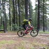
The north section terrain rolls nicely, without any super-long grinding uphills. That said, the descents are still fun, and there are plenty of twists and turns to keep you on your toes when the speed edges up. There are a few root steps to negotiate and a couple of bridges to cross, but nothing too tricky.
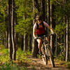
The south side is kinda flat, with elevation changes coming largely from dips into gullies instead of hill climbs. There are lots of roots, as the trail winds through mature stands of pine and spruce above the Jumpingpound creek.
This trail is great for the intermediate rider who wants to get out for a quick rip after work. At ~9km in length, it will take less than an hour if you're cleaning the climbs and not waiting for anyone.
This trail also suits beginners and children very well, what with the south half being fairly flat and reasonably wide. Starting at the east end and travelling west to do an out-and-back of the south side is a great way for a new-ish rider to experience "real" mountain biking with few consequences.
Need to Know
This trail is shared with hikers, cows and horses. There is a shooting range a few km to the SW, so if you hear some odd pops and cracks, that's all it is. Cell phone coverage is not great.
Description
This trail can be started from the Pinetop day use area or the Pine Grove group camp. Assuming you're heading south on Hwy 68 from Hwy 1 to get to the ride, you'll encounter Pinetop first, on the left just after the road switches from pavement to gravel. This is where most people park, and there are washrooms, picnic tables and trash cans here as well. Pine Grove is around 3km further down the road on the left.
You can ride this loop clockwise or counter-clockwise, although most people ride it counter-clockwise.
From Pinetop, cross the gravel road and look for the trail sign and some singletrack heading up the hill. The trail climbs for a while, winding back and forth through the mixed forest. Keep an eye out for fresh cow patties! If you see one, you're going to see more. This first section rolls and twists as it climbs without getting too steep. A short descent will take you to an old barbed wire fence/gate. Past that, the trail makes a hard right and climbs up a little before leveling out and continuing on its way.
The rest of the north side is similar, with punchy climbs followed by short descents. You'll pop in and out of the trees, with the best views coming at the crest of each climb. There are two bridges to cross, with interesting entrances/exits. Roots come in waves, with a few more showing up on the western half of the north section.
At around the 4km mark, you'll crest a hill that represents the last piece of significant climbing on the loop - it's all downhill from here! Okay, there are a few short rises along the way, but momentum and a few pedal strokes will be enough get you through. Pinning it down to the road and across to the south side will put you on the return leg.
The south side starts off on a flattish grassy area studded with trees. The trail snakes along the edge of the denser forest until you cross a gravel trail/road and dive into the woods. The trail is wider here than on the north side, and there are more large roots to navigate. Regardless, it's easy enough to thread your way through. There are a few spur trails off to the left which will lead to picnic areas or camping. Stay on the main trail and you won't get lost.
When you reach the gullies, remember to shift to an easier gear early, as the climb out can be a bit loose and they are a wee bit steep. There's also a set of stairs leading down into a gully. The spacing is a little off, and there's a hard left at the bottom, so use your best judgement. There are a couple of skinnies/bridges past this point, but nothing too hairy.
Keep your speed up over the last mile or so, and you can probably coast up at least a couple of small rises. This is a great time to see if you can drop your riding buddies, as sightlines are great and there are enough chicanes and roots to keep things interesting. Keep an eye out for the parking lot on the left - you're done!
Contacts
Shared By:
David Mills
with improvements
by Jason Pemberton

 Continue with onX Maps
 Continue with Facebook


 Intermediate


 Northern Flow
 Southern Flow
 Moosepackers Loop
 Calgary, AB


0 Comments