
 Continue with onX Maps
 Continue with Facebook


 Difficult

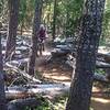
“Narrow singletrack, steep climbs and descents, and an option to shuttle mean plenty of variety. ”


10.9
Miles17.5
KMSingletrack
 Difficult
Local Club: Disciples of Dirt (DOD)
Feb 21, 2024: Open Position
Feb 19, 2024: Whypass Cleanup: Round Three
Feb 12, 2024: Whypass Cleanup: Round Two
Land Manager: USFS - Willamette National Forest Office
 Pyramids Big Loop
50.4 mi 81.1 km • 11,643' Up 3548.78 m Up • 11,637' Down 3547.09 m Down

 McKenzi…, OR
 Cultus Lake Loop
12.4 mi 19.9 km • 580' Up 176.91 m Up • 580' Down 176.8 m Down
North Fork - Farewell Loop
15.6 mi 25.0 km • 1,590' Up 484.76 m Up • 1,584' Down 482.88 m Down
Deschut…, OR
Swampy to Mrazek
26.3 mi 42.3 km • 1,608' Up 490.13 m Up • 3,748' Down 1142.34 m Down
Deschut…, OR
High Cascades 100
105.0 mi 169.0 km • 9,314' Up 2838.84 m Up • 9,308' Down 2837.05 m Down
Bend, OR
 Lawler Shuttle
9.0 mi 14.4 km • 672' Up 204.72 m Up • 3,480' Down 1060.59 m Down
Oakridge, OR


1 Comment