
 Continue with onX Maps
 Continue with Facebook


 Easy
Easy


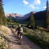
“Gentle grades and valley floor views along a mostly dirt surface bike path. ”


3.5
Miles5.6
KMPaved Path


0 Comments