
 Continue with onX Maps
 Continue with Facebook


 Easy/Intermediate

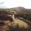
“Ride the ridge between El Moro and Emerald Canyons down to the ocean. ”


3.8
Miles6.1
KMDoubletrack
 Easy/Intermediate
Land Manager: California State Parks - Crystal Cove
 Arduous Thrill
7.7 mi 12.4 km • 1,017' Up 310.01 m Up • 1,013' Down 308.65 m Down

 San Joa…, CA
 Bandit Loop
9.6 mi 15.5 km • 988' Up 301.14 m Up • 993' Down 302.56 m Down
Aliso V…, CA
5 Oak, Cholla, Rock-it
6.7 mi 10.7 km • 1,101' Up 335.69 m Up • 1,115' Down 339.7 m Down
Aliso V…, CA
 Nyes Laguna Beach Thigh Killer
11.0 mi 17.6 km • 2,094' Up 638.35 m Up • 2,093' Down 637.97 m Down
Aliso and Wood Canyons Tour
14.7 mi 23.7 km • 1,519' Up 462.86 m Up • 1,519' Down 462.96 m Down
Aliso V…, CA
Westridge Loop
2.4 mi 3.9 km • 300' Up 91.44 m Up • 299' Down 91.28 m Down
Rancho…, CA


1 Comment