Use onX Backcountry to explore the terrain in 3D, view recent satellite imagery, and more.
Now available in onX Backcountry Mobile apps!
For more information see this post.
“Have fun! The trail is flowy and when it gets steeper and gravely, stand firm.
”
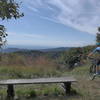
Starting at road Nr.753, there should be a hiking sign marking the direction down to the town of Volce. The trail is used frequently so it's got good sight lines.
Starting with some bends and later more flowy sections. In the second half, you'll have to ride on steep gravel. At the end, there is an easier doubletrack which will bring you back to the first houses of Volce and to road Nr.753.
Moderately steep. Uneven terrain with small rocks or roots.
Sizable rocks & roots. Steep sections.
Steep. Some technical terrain and limited alternate lines.
Very steep. Technical terrain with no alternate lines.
Difficulty Rating
Average from 1 vote:
Difficult
Your Rating
Virtual Tour of Kovacic planina: Lower Singletrack
We use cookies to improve your browsing experience, to show you
personalized content, and for statistical purposes. By continuing
to navigate our website, you accept our use of cookies. Read our
Privacy Policy to learn more.

 Continue with onX Maps
 Continue with Facebook


0 Comments