
 Continue with onX Maps
 Continue with Facebook


 Difficult


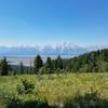
“A steep climb from the southwest toward the Cache Creek trails and the top of Snow King. ”


5.1
Miles8.2
KMSingletrack


0 Comments