
 Continue with onX Maps
 Continue with Facebook


 Intermediate/Difficult

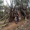
“A beautiful backcountry-style trail through old aspen groves. ”


2.7
Miles4.3
KMSingletrack
 Intermediate/Difficult
Land Manager: USFS - White River National Forest Office
 Coal Creek to Thompson Link Up
24.2 mi 39.0 km • 4,239' Up 1292.02 m Up • 4,264' Down 1299.68 m Down

 Prince Creek Quickie
6.9 mi 11.2 km • 875' Up 266.85 m Up • 875' Down 266.83 m Down
 Carbondale, CO
Red Hill Loop
Carbondale, CO
Red Hill Loop
6.1 mi 9.8 km • 1,091' Up 332.65 m Up • 1,091' Down 332.39 m Down
 CMC Racecourse
4.7 mi 7.5 km • 587' Up 178.82 m Up • 587' Down 178.95 m Down
Power of Four - Old Course
36.6 mi 58.9 km • 8,275' Up 2522.37 m Up • 8,769' Down 2672.64 m Down
Snowmas…, CO
2023 Snowmass 50 Mountain Bike Race
26.7 mi 42.9 km • 4,233' Up 1290.33 m Up • 4,245' Down 1293.96 m Down
Snowmas…, CO


0 Comments