
 Continue with onX Maps
 Continue with Facebook


 Intermediate/Difficult

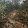
“This trail makes a fairly easy, twisty climb through remote terrain. ”


4.9
Miles7.9
KMSingletrack
 Intermediate/Difficult
Land Manager: USFS Mount Rogers National Recreation Area
 The Long Loop
12.5 mi 20.1 km • 1,903' Up 579.98 m Up • 1,925' Down 586.69 m Down

 Marion, VA
 Mountain Do Tri: MTB
10.3 mi 16.5 km • 1,885' Up 574.64 m Up • 1,865' Down 568.32 m Down
Marion, VA
 Wild Steer 6202
15.1 mi 24.3 km • 1,618' Up 493.03 m Up • 1,617' Down 492.95 m Down
Marion, VA
Rush Creek Loop
13.7 mi 22.0 km • 2,461' Up 750.01 m Up • 2,451' Down 747.12 m Down
Chilhowie, VA
Horse Heaven
14.0 mi 22.6 km • 2,561' Up 780.67 m Up • 2,562' Down 780.8 m Down
 Virginia Creeper Trail - Damascus to Whitetop
18.2 mi 29.3 km • 2,039' Up 621.4 m Up • 403' Down 122.92 m Down
Glade S…, VA


0 Comments