Use onX Backcountry to explore the terrain in 3D, view recent satellite imagery, and more.
Now available in onX Backcountry Mobile apps!
For more information see this post.
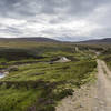
“The Middle Road connects the Upper Road and Lower Road as well as many technical singletracks.
”
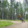
The Middle Road is a pleasant ride through the thick forest above Aviemore known as the High Burnside area. It intersects with the High Burnside Upper Forest Road twice and once with the High Burnside Lower Forest Road as well as a number of technical singletrack descents that run through the forest.
Enjoy exploring, but do get a map, take the MTB Project mobile app or speak with a local as you could easily get lost. If that happens, just head down and you'll end up on the Lower Road which will take you back to Aviemore.
Moderately steep. Uneven terrain with small rocks or roots.
Sizable rocks & roots. Steep sections.
Steep. Some technical terrain and limited alternate lines.
Very steep. Technical terrain with no alternate lines.
Difficulty Rating
Average from 1 vote:
Easy
Your Rating
Virtual Tour of High Burnside Middle Forest Road
We use cookies to improve your browsing experience, to show you
personalized content, and for statistical purposes. By continuing
to navigate our website, you accept our use of cookies. Read our
Privacy Policy to learn more.

 Continue with onX Maps
 Continue with Facebook


 Easy
Easy


0 Comments