Dogs Unknown

E-Bikes
Unknown
Description
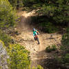
Starting from the el Nogal day use parking area, head into the forest and cross a small bridge over the rio Fernando de Taos. Climb uphill about 1/10th of a mile until you reach a trail junction. This gets most of the climbing out of the way. Take a sharp left at the junction and enjoy an easy downhill through the forest on the upper portion of the trail. Although there is a pretty good cross slope, the singletrack is wide and generally easy. There is one optional advanced line through a wash.
At the far end, you'll cross the stream for the return trip just before you reach the la Vinateria trailhead. A short side trail will take you to this alternative parking area. The return trip along the stream is a little bit more difficult with narrower singletrack, some roots, short dips and climbs, narrow passages between trees, and low overhanging trees.
Contacts
Shared By:
Lost Justpastnowhere

 Continue with onX Maps
 Continue with Facebook


 Easy/Intermediate


0 Comments