
 Continue with onX Maps
 Continue with Facebook


 Difficult

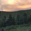
“A rough climb into the trees. ”


2.3
Miles3.7
KMSingletrack
 Difficult
Land Manager: USFS - Carson National Forest
 Talpa Traverse (from El Nogal)
9.9 mi 15.9 km • 1,066' Up 324.95 m Up • 1,063' Down 324.03 m Down


 Rift Valley Trail
12.6 mi 20.4 km • 723' Up 220.22 m Up • 723' Down 220.36 m Down
 Mondragon Loop
15.0 mi 24.2 km • 2,428' Up 740.19 m Up • 2,430' Down 740.79 m Down
 South Boundary Trail #164 - IMBA EPIC
21.4 mi 34.4 km • 1,608' Up 490.05 m Up • 4,384' Down 1336.37 m Down
Angel Fire, NM
South Boundary: 70 to Juan (Short Shuttle)
29.3 mi 47.1 km • 3,690' Up 1124.85 m Up • 4,965' Down 1513.47 m Down
Angel Fire, NM
John Dunn's Heavy Horse
22.3 mi 35.9 km • 1,857' Up 566.04 m Up • 1,840' Down 560.69 m Down


0 Comments