Dogs No Dogs

E-Bikes
Unknown
Description
Kuaokala Firebreak Road climbs from near the Kanea Point Satellite Tracking Station to the intersection with Kealia trail and
Mokuleia Firebreak Road. The alternative road to the Kanea Point Satellite Tracking Station from the west coast, requires a permit from the Division of Forestry and Wildlife and will require passing multiple guard stations. Details on the permitting process can be found,
here. (Note that the Air Force occasionally closes the road even if you have a permit).
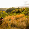
Kuaokala Firebreak Road has good forest cover, which will be welcome as it blocks out the hot tropical sun, but there are enough breaks in the foliage to give some awesome views of the Pacific and the Oahu Coast.
The best way to experience this forest road is as part of the
Peacock Flats Loop.
Contacts
Shared By:
Lost Justpastnowhere

 Continue with onX Maps
 Continue with Facebook


 Intermediate


0 Comments