
 Continue with onX Maps
 Continue with Facebook


 Intermediate/Difficult

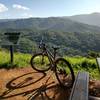
“After a creek crossing, look for this very steep singletrack trail. ”


1.7
Miles2.7
KMSingletrack
 Intermediate/Difficult
Land Manager: California State Parks - Henry W. Coe State Park
 Flat Frog to Middle Ridge (Henry W. Coe State Park)
10.4 mi 16.7 km • 2,226' Up 678.59 m Up • 2,226' Down 678.53 m Down


 South Henry Coe Singletrack Tour
27.8 mi 44.8 km • 6,143' Up 1872.51 m Up • 6,153' Down 1875.36 m Down
San Martin, CA
 Harvey Bear Tour
14.0 mi 22.5 km • 1,082' Up 329.69 m Up • 1,082' Down 329.72 m Down
Mine Hill Loop
6.1 mi 9.8 km • 1,155' Up 352.04 m Up • 1,152' Down 351.23 m Down
Rancho San Vicente and Calero Park
9.4 mi 15.2 km • 713' Up 217.45 m Up • 713' Down 217.24 m Down
Almaden…, CA
Mount Umunhum Loop
13.9 mi 22.4 km • 2,408' Up 733.96 m Up • 2,423' Down 738.53 m Down


0 Comments