
 Continue with onX Maps
 Continue with Facebook


 Difficult

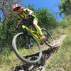
“The crown jewel of HCSNA covering the best territory with terrain varying from extremely rocky to flat riding on dirt. ”


6.5
Miles10.5
KMSingletrack
 Difficult
Land Manager: Texas Parks and Wildlife Department (TPWD)
 Just Past Nowhere
23.5 mi 37.8 km • 1,754' Up 534.6 m Up • 1,745' Down 531.77 m Down

 Bandera, TX
 Hill Country State Natural Area Highlights
15.4 mi 24.8 km • 1,201' Up 366.13 m Up • 1,199' Down 365.45 m Down
 Kerrville Schreiner Park
8.9 mi 14.3 km • 380' Up 115.91 m Up • 382' Down 116.55 m Down
Kerrville, TX
Outer Loop
12.0 mi 19.2 km • 797' Up 242.9 m Up • 797' Down 243.01 m Down
Flat Rock Ranch, near Comfort, TX
19.0 mi 30.6 km • 1,532' Up 466.99 m Up • 1,538' Down 468.7 m Down
Comfort, TX


1 Comment