Dogs Off-leash

Features
Views

This is a shared use (motorized) route with a seasonal closure from January to March.
The only legal access to the trail is from the Horse Cove Gap trailhead, on the eastern end of the route. A daily fee of $5 per vehicle is required.
Description
Ready for a challenge?! Trail #29 climbs it's way up to the fire tower from Dry Creek Road just outside downtown Johnson City. This nearly 13 mile rugged linear route is a beast of a trail that runs along the ridgeline of Buffalo Mountain where you'll see everything from rocks, smooth hardpack, crazy steep climbs, berms, did we mention ROCKS, and everything in between. There are several steep climbs and descents, the biggest going in and out of the Pinnacle Road drainage.
Riders can also shuttle up forest road 188 (also on Dry Creek Road) by car, or use it as an alternate/easier option to reach to the top. Most use the fire-tower parking lot as the turn around point (easily identified with a yellow gate blocking off car traffic to the tower), or for the ultimate challenge you can drop down the back side (as this route map shows) before your return trip. With nearly 2,000ft of climbing it's no surprise that this trail is popular with e-bikes.
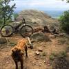
Plan some extra time to take in the incredible views along the way...we promise it's worth the effort!
Trail #29 is multiuse with ATV's and while you won't exactly find a traffic jam, as with any multidirectional trail, always be aware of your surroundings and keep your bike in control at all times. There is a $5 per vehicle parking fee in the feed tube at the trailhead, so bring some cash.
Contacts
Shared By:
Leslie Kehmeier
with improvements
by Chad Wolfe

 Continue with onX Maps
 Continue with Facebook


 Difficult


0 Comments