
 Continue with onX Maps
 Continue with Facebook


 Intermediate

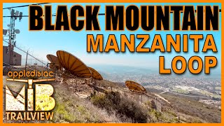
“A ridge trail with views to the east and west. ”


1.0
Miles1.6
KMSingletrack
 Intermediate
Land Manager: City of San Diego - Parks & Recreation
 Lilac Miners Peak Loop
7.8 mi 12.6 km • 1,054' Up 321.19 m Up • 1,054' Down 321.33 m Down

 Penasquitos Tour
10.8 mi 17.5 km • 825' Up 251.36 m Up • 816' Down 248.61 m Down
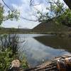
Lake Hodges North Side
10.2 mi 16.4 km • 294' Up 89.75 m Up • 294' Down 89.75 m Down
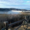
 Escondido, CA
 Elfin Forest
9.6 mi 15.4 km • 1,957' Up 596.49 m Up • 1,929' Down 587.92 m Down
La Costa Preserve - South Side Access
8.8 mi 14.1 km • 1,216' Up 370.54 m Up • 1,216' Down 370.49 m Down
San Clemente/Rose Canyons
15.9 mi 25.5 km • 628' Up 191.45 m Up • 627' Down 191.26 m Down


0 Comments