Use onX Backcountry to explore the terrain in 3D, view recent satellite imagery, and more.
Now available in onX Backcountry Mobile apps!
For more information see this post.
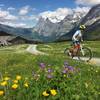
“A gravel and paved path with some dirt and some cars, used as a long connector.
”
Follow the signs carefully and you'll be off the main road almost entirely. There are side roads, paths, and farm roads almost the entire way - keep you eye out for the red "bike" signs.
This connector is easy, and downhill, with some pretty farms. The scenery and nature are pretty limited compared to other trails around here though.
Moderately steep. Uneven terrain with small rocks or roots.
Sizable rocks & roots. Steep sections.
Steep. Some technical terrain and limited alternate lines.
Very steep. Technical terrain with no alternate lines.
Difficulty Rating
Average from 1 vote:
Easy
Your Rating
Virtual Tour of Grindelwald to Zweilutshinen
We use cookies to improve your browsing experience, to show you
personalized content, and for statistical purposes. By continuing
to navigate our website, you accept our use of cookies. Read our
Privacy Policy to learn more.

 Continue with onX Maps
 Continue with Facebook


 Easy
Easy


0 Comments