The recommended start for this trail is at the State Draw
Trail just off Divide Rd.
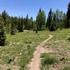
From this trailhead, which is marked by a kiosk, follow the singletrack that takes off across the meadow and slightly uphill. At about a 1/2 mile, the singletrack joins a dirt road. Just up the road is the "To Red Canyon" sign. Past the singletrack gate, the trail heads through dense forest, open meadows, and aspen groves.
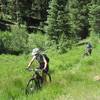
After three miles, the trail begins descending, sometimes steeply, towards Red Canyon Creek. The trail is in varying states of maintenance, with sweet singletrack through the forest, isolated doubletrack, and places where water erosion has turned the fall-line trail into a three-foot deep trough.
After crossing Red Canyon Creek, the trail climbs out of the drainage, then continues a mellower descent to County Rd. 90. The suggested return route is to take County Rd. 90 back to your starting point. This is a steep climb for a few miles, then becomes rolling with some fast descents. In 2016, a landslide has closed the road to vehicles, but the closure is easily passable on a mountain bike.
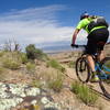
Overall, Red Canyon
Trail is a nice, remote-feeling ride with panoramic views of the Wilson mountain range and Lone Cone. Be aware that this ride feels remote, and is remote. Parties should be self-sufficient and prepared for self-rescue if something goes wrong. Full finger gloves and long sleeves are recommended due to the heavy trailside vegetation.

 Continue with onX Maps
 Continue with Facebook


 Very Difficult


0 Comments