
 Continue with onX Maps
 Continue with Facebook


 Difficult

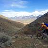
“Riders will enjoy the rugged ridgeline and dense pine singletrack travel on this section of the CDT. ”


19.8
Miles31.8
KMSingletrack
 Difficult
Land Manager: USFS - Salmon-Challis National Forest Office
 Twelvemile to Lime Creek
12.9 mi 20.7 km • 2,013' Up 613.58 m Up • 4,419' Down 1346.8 m Down

 Rippey Spring Loop
11.0 mi 17.8 km • 1,525' Up 464.94 m Up • 1,526' Down 465.24 m Down
Slump Gulch Loop
7.1 mi 11.5 km • 443' Up 134.94 m Up • 443' Down 135.04 m Down
 Enduro Loop
9.4 mi 15.1 km • 675' Up 205.81 m Up • 675' Down 205.67 m Down
Salmon, ID
 Elk Loop
9.4 mi 15.2 km • 1,477' Up 450.25 m Up • 1,477' Down 450.08 m Down


0 Comments