
 Continue with onX Maps
 Continue with Facebook


 Difficult

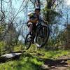
“Inner loop in the Sand Hill area with a white-knuckle descent. ”


1.4
Miles2.2
KMSingletrack
 Difficult
Local Club: River Valley Mountain Bike Association
Land Manager: Mountwood Park
 Mountwood Park Grand Tour Loop
22.4 mi 36.0 km • 2,396' Up 730.39 m Up • 2,397' Down 730.48 m Down

 Deerwalk, WV
 Johnson T. Janes Park Loop
1.9 mi 3.0 km • 84' Up 25.62 m Up • 84' Down 25.69 m Down
 Marietta Lunch Loop
5.9 mi 9.4 km • 497' Up 151.52 m Up • 497' Down 151.39 m Down
Marietta, OH
North Marietta Tour
13.1 mi 21.1 km • 1,534' Up 467.52 m Up • 1,533' Down 467.38 m Down
Marietta, OH
 Greenwood/Scenic River Trail Classic
12.9 mi 20.7 km • 1,085' Up 330.66 m Up • 1,087' Down 331.27 m Down
Newport, OH
Wayne National Forest Epic
34.8 mi 55.9 km • 3,227' Up 983.67 m Up • 3,256' Down 992.28 m Down
New Mat…, OH


 All Clear


0 Comments