
 Continue with onX Maps
 Continue with Facebook


 Difficult

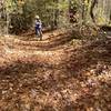
“A steep doubletrack connector. ”


1.6
Miles2.6
KMDoubletrack
 Difficult
Land Manager: NPS - Big South Fork Nat. River and Rec. Area Office
 Kentucky Trail Loop
18.6 mi 29.9 km • 1,810' Up 551.82 m Up • 1,792' Down 546.14 m Down


 Chestnut Ridge Loop
11.2 mi 18.1 km • 770' Up 234.56 m Up • 770' Down 234.72 m Down
Grand Gap Loop
6.4 mi 10.4 km • 875' Up 266.56 m Up • 872' Down 265.76 m Down
Oneida, TN
Collier Ridge/ West Bandy / Duncan Hollow at Big South Fork
13.3 mi 21.4 km • 1,377' Up 419.57 m Up • 1,377' Down 419.62 m Down
Big South Fork - IMBA EPIC
34.2 mi 55.0 km • 2,026' Up 617.62 m Up • 2,027' Down 617.93 m Down
Oneida, TN
The Forty 5
45.5 mi 73.3 km • 3,815' Up 1162.79 m Up • 3,455' Down 1053.22 m Down
North C…, KY


0 Comments