
 Continue with onX Maps
 Continue with Facebook


 Difficult

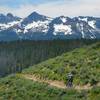
“A trail through glacial valley with expansive views. ”


9.1
Miles14.6
KMSingletrack
 Difficult
Local Club: Southwest Idaho Mountain Bike Association
Land Manager: USFS - Boise National Forest Office
 Decker Creek Loop
22.0 mi 35.4 km • 4,212' Up 1283.96 m Up • 4,246' Down 1294.14 m Down

 Idaho City, ID
Granite - Smith Traverse
Idaho City, ID
Granite - Smith Traverse
21.9 mi 35.3 km • 3,610' Up 1100.39 m Up • 3,707' Down 1129.79 m Down
Boundary to Little Casino
13.8 mi 22.2 km • 2,517' Up 767.13 m Up • 2,894' Down 882.11 m Down
Potato Mountain Ride
13.7 mi 22.1 km • 1,165' Up 354.97 m Up • 1,163' Down 354.57 m Down
 Little Casino to Big Casino
20.1 mi 32.4 km • 3,749' Up 1142.61 m Up • 3,753' Down 1143.95 m Down
Challis, ID
Smoke and Fire Route
413.2 mi 665.0 km • 29,903' Up 9114.5 m Up • 29,898' Down 9113.01 m Down
Boise, ID


0 Comments