
 Continue with onX Maps
 Continue with Facebook


 Easy/Intermediate

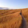
“A ridge ride alternative to Toll Road Trail #27A and Cottonwood Creek Trail #27. ”


1.0
Miles1.6
KMDoubletrack
 Easy/Intermediate
Land Manager: Ridge to Rivers
 Shane's Loop
8.3 mi 13.4 km • 926' Up 282.32 m Up • 922' Down 281.11 m Down

 Red Cliff to Bobs to Lower Hulls
9.9 mi 15.9 km • 1,504' Up 458.56 m Up • 1,508' Down 459.49 m Down
 Boise, ID
Double D
Boise, ID
Double D
17.7 mi 28.5 km • 2,596' Up 791.12 m Up • 2,594' Down 790.71 m Down
Boise, ID
 The Big Potato
42.0 mi 67.6 km • 5,794' Up 1765.93 m Up • 5,820' Down 1774.04 m Down
Boise, ID
Homestead to Highland Valley
10.2 mi 16.4 km • 1,620' Up 493.65 m Up • 1,657' Down 504.93 m Down
Stack Rock Loop
11.4 mi 18.3 km • 1,144' Up 348.62 m Up • 1,146' Down 349.2 m Down
Boise, ID


0 Comments