
 Continue with onX Maps
 Continue with Facebook


 Intermediate

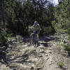
“A fine new connnector linking east (Cedro Peak) to west (Otero Canyon) Manzanitas. ”


2.2
Miles3.6
KMSingletrack
 Intermediate
Local Club: AMBA
Land Manager: USFS - Cibola National Forest Office
 Coyote/Chamisoso Loop
11.2 mi 18.1 km • 1,177' Up 358.75 m Up • 1,182' Down 360.14 m Down


 Medio Sandia
14.6 mi 23.5 km • 2,257' Up 687.9 m Up • 2,264' Down 690.02 m Down
 Golden Open Space
11.0 mi 17.8 km • 763' Up 232.42 m Up • 762' Down 232.11 m Down
King of the Mountain, Golden Eagle Loop
12.0 mi 19.3 km • 2,108' Up 642.45 m Up • 2,122' Down 646.81 m Down
Figure Eight Mile Olio
8.6 mi 13.8 km • 1,001' Up 305.12 m Up • 1,001' Down 305.08 m Down
Placitas, NM
Placitas Open Space
5.6 mi 9.1 km • 569' Up 173.5 m Up • 569' Down 173.38 m Down


0 Comments