Dogs Unknown

E-Bikes
Unknown
Overview
There are a lot of ways to connect the trails at Pandapas Pond to make a ride. This particular loop will give you a great ride without all of the rock gardens on the Gap Mountain side of
Poverty Creek. Rated difficult for the cardio climb up Horsenettle, but for technical riding it's light intermediate, though the descent down
Jacobs Ladder requires skill.
Need to Know
As of 2023, this is no longer a top "recommended route," as new trail construction and the neglect and erosion of some trails have made certain routes more or less popular. This loop can still make for a fun, shorter ride on some of the system's older trails (
Jacobs Ladder is a blast!), but it doesn't highlight all of the main riding styles at Pandapas. Despite all of this, this route can still make for an enjoyable ride.
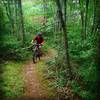
Description
Starting at the map kiosk from the main parking lot at Pandapas Pond, head to the left to pick up Horsenettle. You'll ride for about half-a-mile on doubletrack before making a sharp left onto the trail. The climbing starts immediately :) There are a few places on the way up to do a brief rolling recovery, but it's pretty much a solid 2-mile climb up. You're about half way when you make a right onto the fireroad portion of the trail.
The fire road has 3 false summits where you think you've reached the top, only to see a short descent followed by another climb. You're just about at the top when you pass the communication tower on your left. Salvation can be found at the circle which marks the end of the climb and gets you back into singletrack. The singletrack is a short, fast section that will take you to a very short and fast section of fire road to the top of
Jacobs Ladder - It's real easy to blow past the entrance of the trail, so look for it right after the small mogul in the road (you can catch air on the mogul if you're going fast enough).
Jacobs Ladder has 2 tight switchbacks at the top and one lazy one. After this, it's pretty much a straight shot down the hill. The top section has a good amount of loose rocks to navigate. The middle section levels out a bit and you have to shoot a gap between 2 small trees so watch out if you have ultrawide bars. The bottom half gets a bit hairy with erosion channels creating 2 rooty drops. If you're not ready for these drops you'll crash hard so either plan to drop them or dismount - You won't be able to simply roll them. At the bottom of Jacob's Ladder you'll cross the creek and make a right onto the
Poverty Creek Trail.
This section of
Poverty Creek is pretty fast and flowy with one rooty section and one small rock garden. Take the trail down a bit and pick up
Royale, which will be a hard left.
Royale will be a steady climb which starts smooth and ends rocky.
Royale will dump you out at a
Forest Service Road 708, where you'll make a left. This section of road is downhill and very fast, but the surface is quite loose and easy to wash out on. Also, this road is opened to traffic and while it is very lightly traveled you have to be on the lookout for cars. The trailhead for QueenAnnes Lace is down a bit on the right and again, it's real easy to blow right past it so keep an eye out for the marker post on your right.
QueeneAnnes Lace is a nice, undulating roll through the woods. Nothing technical, but just as the trail lets out back at FSR 708 there is a series of nasty downhill roots. You want to carry enough speed to roll the roots but not so much that you shoot out into the road. Make a right onto the road and jump back onto the
Poverty Creek trail which is only about 100 feet or so on your left, then head left on
Poverty Creek to head back to the parking lot.
You'll be on
Poverty Creek for about 2.5 miles, half of which will be backtracking from where you got off
Jacobs Ladder and onto
Royale.
Poverty Creek likes to keep mudholes around for a good while after a rain. And the closer you get to the parking area and Pandapas Pond, the more likely it is that you'll encounter other trail users.
Poverty Creek finishes up with a real short but steep and rocky climb up to the park entrance. You'll see the main parking lot where you started directly across the road.
History & Background
Nothing. Dinosaurs. Cavemen. Indians. Columbus. Pilgrims. Gary Fisher. You.
Contacts
Shared By:
Michael Bruce
with improvements
by Jackson P

 Continue with onX Maps
 Continue with Facebook


 Difficult

 Pandapas Pond "Challenging" Loop

 Rowdy Dawg XC Race Course
 Mountain Top Trot

 RockStar TRAIL Route


4 Comments