Dogs Unknown

E-Bikes
Unknown
Features
Views
Overview
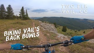
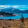
This is one route option for those looking to ride Two Elk down, getting there and back all by bike, as opposed to shuttling or taking the chair lift.
The initial 10-mile climb isn't difficult but it is long. The 10-mile Two Elk descent is of course amazing fun and very scenic. The remaining 10 miles is mostly flat on dirt road, paved road in Minturn, and paved multi-use paths.
Overall, this is a long, strenuous ride and you'll want to bring plenty of food and water. Rated black/difficult due to the long descent down Two Elk being fast and narrow with some steep exposure and rocky sections.
Need to Know
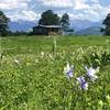
Minturn has a few bars/restaurants and a gas station, good place to rest and refuel because there's still 7.5 miles of mild pedaling back to Vail. Despite being high elevation, this area can get pretty hot in the summer so it's best to start early. Also being high elevation be sure to check the weather and plan accordingly since you'll be out for a long time.
Description
This is a big ride starting in Vail resort. Starting with a 10-mile and about 3,600'-climb on the north/northeast side on maintained dirt roads followed by doubletrack and non-maintained dirt roads. The climb isn't very steep but being 10 miles it starts to feel difficult towards the top.
The 10-mile amazing scenic descent takes you down
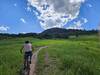
Two Elk Trail, then a few miles on flat road to Minturn (good place to stop and refuel if needed). From Minturn, it's about 7.5 miles back to Vail on some dirt/paved roads, but mostly paved multi-use paths. In my experience the last 5 miles on paved path was strenuous due to the length and time of riding at that point, plus its ever so slightly uphill going back to Vail.
The total time it took was 5.5 hours including breaks, everyone's pace is different of course but be prepared for a long grueling day regardless.
Starting in Vail Village, ride up
Gitalong Road. After about 0.8 miles(as Gitalong does a hairpin turn), go left on Mill Creek Road (aka Village Trail on MTB Project). After about 2.3 miles, you'll pass another road and will continue east on Mill Creed Road (aka
Mill Creek Trail on MTB Project).
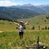
At this point it goes from a maintained dirt road to doubletrack and not-so-well maintained dirt road. After about 6 miles, you can either do some hike-a-bike to the left to reach an 11,800' peak for some amazing views, or continue right to the ridge where the descent will start.
This is a good spot for a long break and to refuel, there's a long descent and still some pedaling back to Vail.
From the top of the climb, go west down Commando Run
Connector for about 0.5 to 0.8 miles (depending if you went to the peak or not), this has a few rocky sections along the way. Keep a close eye out for Two Elk
Connector to the left (south), which you can see will go past the top of the Mongolia T-bar lift. Take the Two Elk
Connector south about 1.6 miles down to
Two Elk Trail. Take
Two Elk Trail west 10 miles where it dumps you out to a dirt road. Take the dirt road a few miles north to Minturn.
Minturn is good spot for a break and getting some food/water if needed since you still have about 7.5 miles to go.
After going through Minturn on the north side of town, stay right/north on Main Street as it goes across the bridge (not recommended to continue on the highway here because there's practically no shoulder). Take a right just past the bridge on Rail Rd, which will continue north as Minturn Rd. Continue north until you cross the river again, then take the paved bike path north, eventually needing to take the shoulder along the road for a short distance.
Shortly after going under I-70, you'll see the paved multi-use trail to the right/east, take that all the way back to Vail.
Shared By:
John S.

 Continue with onX Maps
 Continue with Facebook


 Difficult


0 Comments