
 Continue with onX Maps
 Continue with Facebook


 Difficult

“Pleasant singletrack diagonally across the hill. ”


0.4
Miles0.7
KMSingletrack
 Difficult
Land Manager: California State Parks
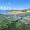
 Coyote Point Trail
8.6 mi 13.8 km • 289' Up 88.18 m Up • 289' Down 88.04 m Down


 Arnold Rim Trail
17.3 mi 27.9 km • 2,851' Up 868.9 m Up • 2,851' Down 868.95 m Down
Jenkinson Lake aka Sly Park
8.2 mi 13.2 km • 680' Up 207.14 m Up • 657' Down 200.22 m Down
 McKays Dam Road With A Loop
7.1 mi 11.4 km • 725' Up 221.12 m Up • 724' Down 220.62 m Down
Big Trees Loop
16.5 mi 26.5 km • 1,700' Up 518.07 m Up • 1,694' Down 516.33 m Down
South Grove Loop
11.5 mi 18.5 km • 1,243' Up 379.01 m Up • 1,243' Down 378.78 m Down


0 Comments