Dogs Unknown

E-Bikes
Unknown
Need to Know
Despite the trail naming confusion, the route is mostly intuitive when you are out there. Regardless, wrong turns could be fun. Plus you might be able to Caribou Trail or Strawberry Creek trail to MTB Project.
Description
This trails helps make an enjoyable lollipop loop with
Strawberry West if you are starting from either the Doe Creek trailhead or the High Lonesome Hut trailhead. Thanks to the folks who have done recent trail work and put in some nice bridges where needed.
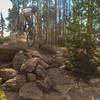
The trail travels through a mostly pine tree dominant forest over a crushed granite trail surface with plenty of rocks to navigate and a few easy rock garden areas. The trail can be done either direction.
Many trails in this area have name "Strawberry" in them and there does not seem to be an agreement across many platforms about what trails are what (even NFS website does not clarify and in hind site I should have taken pictures of the trail intersections). I apologize in advance of the description below...
FROM HIGH LONESOME HUT PARKING AREA: follow the directions on MTB Project for
Strawberry Creek West Trail. After taking a left at the trail junction with Caribou Trail (which seems not to exist to the right), you'll shortly come to another trail intersection.
A right at this fork will put you in a counterclockwise loop on Strawberry East which T-intersects with
Strawberry West. Take a left and you'll be heading back to your car. A left at the original fork will put you on
Strawberry West. You'll see private property signs on your right for the entire meadows before you. At the next intersection with Doe Creek, stay straight/right on
Strawberry West. You'll have about a mile to go before intersecting with Strawberry East which you can miss as
Strawberry West continues straight towards Strawberry Lake. Take a right.
About two miles later, the trail connects with Strawberry Creek. Take a right and a quarter mile later you'll rejoin the trail you biked in on. Take a left to head back to your car. Despite a slight uphill finish on doubletrack this might be the slightly more aesthetic way because of the steep washed-out sections in
Doe Creek Trail.
FROM DOE CREEK TH: The
Doe Creek Trail will T-intersect with
Strawberry West trail. Take a right or left for the loop described above. Going left should make for a slightly more enjoyable experience as you get all the downhill on Strawberry East in one chunk.
Contacts
Shared By:
Chip Loomis

 Continue with onX Maps
 Continue with Facebook


 Intermediate


0 Comments