 Race - Sep 12, 2020
Dogs No Dogs

E-Bikes
Not Allowed
Features
Views
Overview
This route is special because it takes you through some of the most amazing landscapes on the west slope of the Big Horn Mountain range in Northern Wyoming. The course includes some pavement, some singletrack, some gravel roads, and some rougher mountain roads.
Need to Know
The Historic Shell Store serves as the basecamp for all of our pre-race and post-race activities and the Shell Campground is right across the street. The Shell Campground offers RV site, tent sites, cabins, glamping tents, and other off-site rentals.
Description
A hard tail mountain bike, 40mm tire recommended.
Aid Stations are located approximately every 10 miles
You'll head southwest out of Shell on Trapper Creek Road. The first three miles are paved giving you a nice warm up over some rolling hills. Watch for wild turkeys and pheasants crossing the road.
At the Y, you'll stay right and start the gravel. About 4.5 miles into the course, you'll pass the last hay field and get a glimpse up into Trapper Canyon towards your left. Now the work begins as you leave the maintained gravel and start the section of rugged two-track. Pay attention, this part of the course is the most raw and technical.
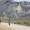
6.5 miles into the course, you'll get an excellent view of Devils Leap. This impressive geological features towers 800 feet in the air. Next, you'll ride through Red Basin. As the sun climbs, these vivd red and orange cliffs will change color. 10.5 miles into the ride, you'll reach the Red Gulch Road, a welcome sight after the tough terrain of Red Basin. At this point you've climbed about 1,100 feet. This backcountry byway will continue to ascend another 1,700 feet until you reach the Alkali Road where you'll turn right and descend the next nine miles towards Hyattville. Take the opportunity to recharge a little – the best is yet to come!
After taking the back entrance into Medicine Lodge Archaeological Site, it's time for a change of scenery. You'll head north on the Cold Springs Road towards Bighorn National Forest. Good thing you rested up as you coasted downhill for nine miles, because you've got a monster climb in front of you – 4,900 feet over 21 miles. Don't worry, that's only 233 feet per mile – you've got this.
Once at the top, another aid station awaits. The cool mountain air will refresh you as you take USFS 17 for the next 23 miles (there will be an aid station in this section as well). You'll pass Paintrock and Medicine Lodge Lakes, Spanish Point, Crooked Creek Hill and Snowshoe Mountain. The big climb may be over but it's not easy street. As you make your way towards US14, you'll face a few more ups and downs on some category 3 roads.
When you reach Ranger Creek Station, make a note to come back. The
Shell Bench Trail #184, an excellent mountain bike trail, starts here (but that's an adventure for another day). When you reach US14, flaggers will warn uphill traffic for you.
Once on US14, it's a feast for the eyes as you descend through Shell Canyon. Shell Creek is your companion as you admire Copmans Tomb, Shell Falls, and Elephant Head Rock. While your legs will appreciate the break, stay alert – hairpin turns and switchbacks require your full attention. When the canyon narrows at the bottom the sound of Shell Creek rushing by tells you you're almost home.
Once at the bottom of the canyon, it's time for the final push home. The next five miles have a gentle descent back to Shell through rolling ranch land. Check out iconic Chimney Rock on your left before cruising back into town.
History & Background
This is the 2nd edition of the Bad Medicine Race/Ride/Tours and the courses take you to some historic places, such as: 1) Medicine Lodge State Park and 2) Red Gulch Road Dinosaur Tracksite.
Contacts
Shared By:
georgia dawg

 Continue with onX Maps
 Continue with Facebook


 Difficult


0 Comments